VisTech.Projects LLC
Planimeter GPS Area Measure
Planimeter GPS Area Measure ist eine App von VisTech.Projects LLC. Veröffentlicht 11 years ago. 2.1.17 Version.
Teilen
Diese App weiterempfehlen
Planimeter GPS Area Measure is a tool to measure distance, area, and perimeter on a map. You can measure manually or by GPS tracking. You can also check the bearing and geo-coordinates of your location and share them. Points can be labeled, saved, and shared in KML format.
This measurement app is useful for outdoor activities and can be used as land surveyor by amateurs and professionals in various industries like sport, farming, landscaping, paving and construction, road building and repairing, real estate business, hiking and travel, fencing, lot building and planning, solar panel installation (roof area estimation), object mapping, lawn design, and many other where land area and distance/length calculations, land survey or maps are involved.
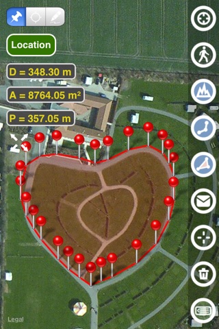
• Accurate distance measurements
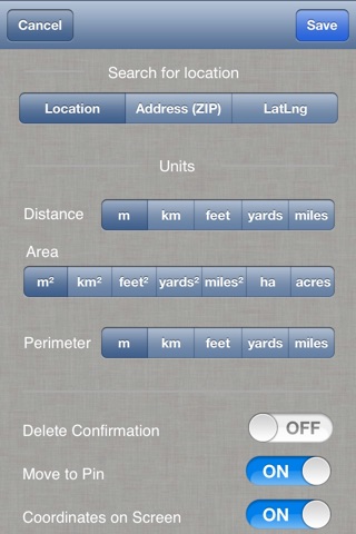
• Metric and Imperial units (m, km, feet, yards, miles, ha, acres)
• GPS accuracy settings (if GPS available)
• Current location search
• Delete selected/last/all points
• Zoom to Fit-in and center points on a screen - quick points search
• Add points by touch
• Add the current location as a point
• Option to center the point added
• Option to show/hide lines
• Preferences: location accuracy, tracking time interval, delete points confirmation, sound option for tracking
• Separate units settings for distance, area, and perimeter.
• Area calculation
• Angle between lines
• Bearings to and from the point
• Forward and backward navigation through points by touch on the Info Panel
• GPS coordinates of a point
• Manage previously saved projects: open, save, share KML files
• KML files created by Planimeter can be imported to GEarth and GMaps to view on a desktop
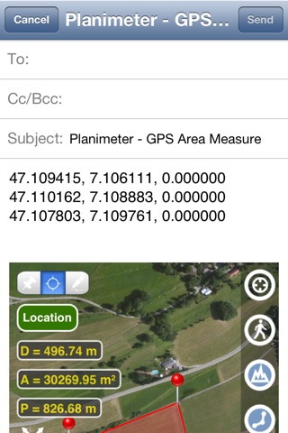
• Send data by email: picture, coordinates as a text message, KML file
• Save KML or TXT in local storage
• Map/Satellite View
• Zoom and Edit points
• Text (address) search
• Find the location by entering the Latitude and Longitude coordinates
• Add points by entering geo-coordinates: Lat and Lng
• Target Mode for accurate pin placement
• Show current coordinates in Target Mode
• Draw (Stylus) Mode
• Notes Mode
• Full-screen option
• GPS TRACKING
• Manual pin placement in GPS Tracking
• outdoor activities: sports, golf (distance between two points or holes), bike tours, trail planning, travelling, quick path measure
• garden and yard: landscape planning, grass cutting, lawn care and mowing, fencing, grass seeding.
• agriculture, poultry, and farming: harvesting, fertilizing, crops (corn, wheat, maize, beet, etc.), planning and estimation, field area measure, paddocks and area fencing for cows, horses, chickens, rabbits, etc.
• solar energy: area estimation for solar panels, flat roof area estimation
• construction: land survey, road sealing, parking lot repairing
• Forestry: objects and tree mapping, damage area estimation, measuring land area
• other: pond size is measured; pole lines planning; movement tracking; get exact GPS coordinates of way-points; fence calculation; geocaching.
If you have any questions about Planimeter and its functionality, please find the How To Use Quick Guide on this page:
https://www.vistechprojects.com/vistech-projects-downloads
Video Demo:
http://youtu.be/unjYbPCIYM0
http://youtu.be/QQMilHVD5e8
If you like the app and find it useful, please support us with your feedback and comments.
Feel free to contact [email protected] with any questions, comments, or bug reports.
This measurement app is useful for outdoor activities and can be used as land surveyor by amateurs and professionals in various industries like sport, farming, landscaping, paving and construction, road building and repairing, real estate business, hiking and travel, fencing, lot building and planning, solar panel installation (roof area estimation), object mapping, lawn design, and many other where land area and distance/length calculations, land survey or maps are involved.
• Accurate distance measurements
• Metric and Imperial units (m, km, feet, yards, miles, ha, acres)
• GPS accuracy settings (if GPS available)
• Current location search
• Delete selected/last/all points
• Zoom to Fit-in and center points on a screen - quick points search
• Add points by touch
• Add the current location as a point
• Option to center the point added
• Option to show/hide lines
• Preferences: location accuracy, tracking time interval, delete points confirmation, sound option for tracking
• Separate units settings for distance, area, and perimeter.
• Area calculation
• Angle between lines
• Bearings to and from the point
• Forward and backward navigation through points by touch on the Info Panel
• GPS coordinates of a point
• Manage previously saved projects: open, save, share KML files
• KML files created by Planimeter can be imported to GEarth and GMaps to view on a desktop
• Send data by email: picture, coordinates as a text message, KML file
• Save KML or TXT in local storage
• Map/Satellite View
• Zoom and Edit points
• Text (address) search
• Find the location by entering the Latitude and Longitude coordinates
• Add points by entering geo-coordinates: Lat and Lng
• Target Mode for accurate pin placement
• Show current coordinates in Target Mode
• Draw (Stylus) Mode
• Notes Mode
• Full-screen option
• GPS TRACKING
• Manual pin placement in GPS Tracking
• outdoor activities: sports, golf (distance between two points or holes), bike tours, trail planning, travelling, quick path measure
• garden and yard: landscape planning, grass cutting, lawn care and mowing, fencing, grass seeding.
• agriculture, poultry, and farming: harvesting, fertilizing, crops (corn, wheat, maize, beet, etc.), planning and estimation, field area measure, paddocks and area fencing for cows, horses, chickens, rabbits, etc.
• solar energy: area estimation for solar panels, flat roof area estimation
• construction: land survey, road sealing, parking lot repairing
• Forestry: objects and tree mapping, damage area estimation, measuring land area
• other: pond size is measured; pole lines planning; movement tracking; get exact GPS coordinates of way-points; fence calculation; geocaching.
If you have any questions about Planimeter and its functionality, please find the How To Use Quick Guide on this page:
https://www.vistechprojects.com/vistech-projects-downloads
Video Demo:
http://youtu.be/unjYbPCIYM0
http://youtu.be/QQMilHVD5e8
If you like the app and find it useful, please support us with your feedback and comments.
Feel free to contact [email protected] with any questions, comments, or bug reports.
Smart erkannt
App-Funktionen
Automatisch aus Beschreibung, Titel und Kategorie erkannt.
🗺️
Interaktive Karten
▶️
Video-Wiedergabe
🎵
Hintergrundmusik & Audio
🖥️
Mac / iPad App
📝
Notizen & Textbearbeitung
💭
Kommentare & Bewertungen