Felt Tip Inc.
Transit Maps
Transit Maps ist eine App von Felt Tip Inc.. Veröffentlicht 17 years ago. 2.2 Version.
Teilen
Diese App weiterempfehlen
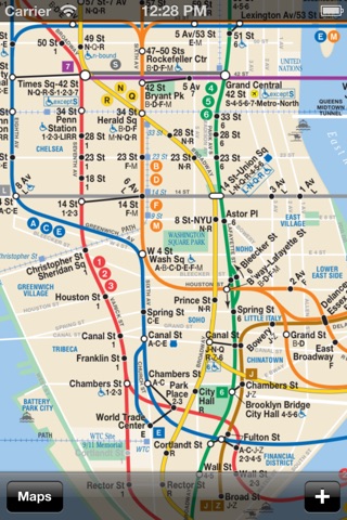
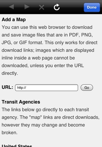
Transit Maps is an offline viewer for very large images. It can download maps and other large image files in PDF, PNG, JPG, and GIF format from the Internet. It is very fast at displaying complex images and it works when network access is unavailable because it slices and saves the image tiles on the device.
It comes with a sample map of the Philadelphia rail system, but you can delete it and add any maps downloadable on the Internet via the built-in web browser. Only the first page of PDF files will be saved.
This app and the included Philadelphia Rail System map are by Lucius Kwok. Made in NYC.
It comes with a sample map of the Philadelphia rail system, but you can delete it and add any maps downloadable on the Internet via the built-in web browser. Only the first page of PDF files will be saved.
This app and the included Philadelphia Rail System map are by Lucius Kwok. Made in NYC.
Smart erkannt
App-Funktionen
Automatisch aus Beschreibung, Titel und Kategorie erkannt.
🗺️
Interaktive Karten
📸
Echte Fotos & Bilder
📄
PDF-Werkzeuge
🗂️
Dateimanager
📦
Offline-Modus
🚌
ÖPNV & Transport